

The AI4AGRI Summer School 2025 brought together researchers, experts, and students in Brașov, Romania, for a week of learning and exchange on Artificial Intelligence (AI) and Earth Observation (EO) for agriculture.
Over six days, the program mixed presentations, discussions, and hands-on sessions, moving from key ideas in big data and deep learning to advanced methods in remote sensing and machine learning.
Sessions covered topics such as working with geospatial datasets, adapting AI models for different data sources, explainable AI, hyperspectral and radar imaging, using EO for weather estimation, monitoring vegetation over time, radar image processing, removing noise from images, and visualising hyperspectral data using AI.
Practical examples showed how these methods can help with crop identification, precision farming, and linking satellite information with ground sensor measurements.
Day 1: Big Data and Deep Learning
Slide from Prof. Martin Werner presentation
Big Data and Deep Learning
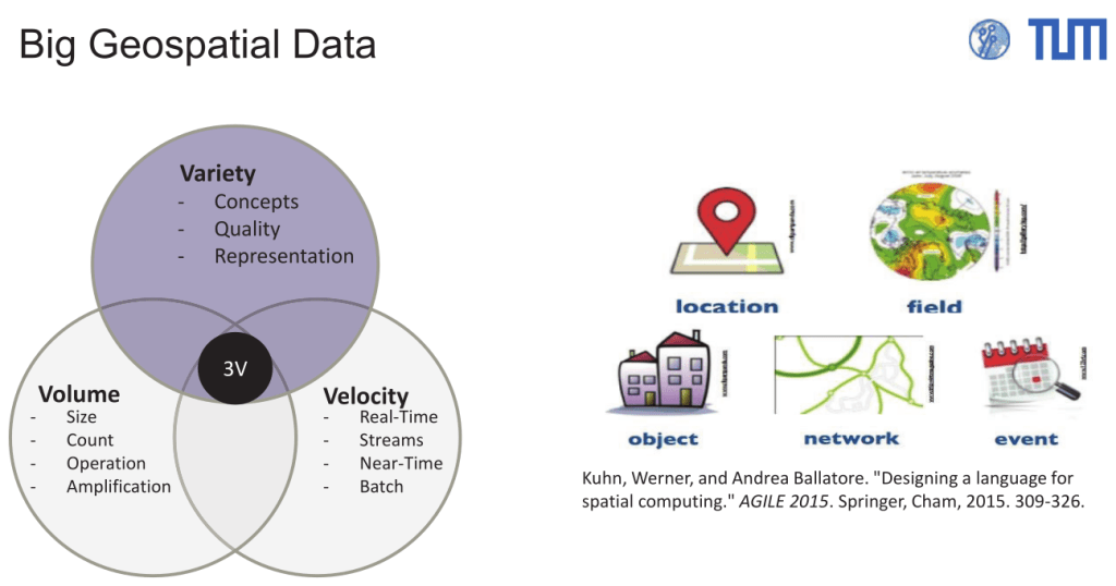
Prof. Martin Werner presentation introduced participants to the concepts and practical approaches behind Big Data and Deep Learning in the context of geospatial applications.
He outlined challenges of managing large and complex geospatial datasets, presented Dask along with practical examples, introduced the summer school participants to OpenStreetMap along with the concept of Bloom filters and geospatial hashing, concluding with an OpenStreetMap and Earth Observation data fusion practical example.

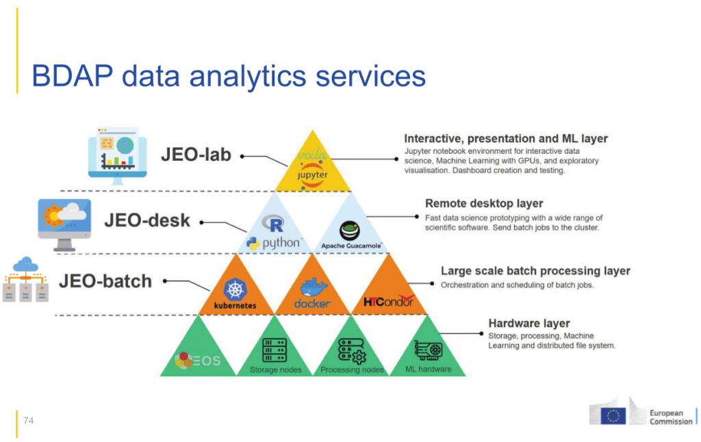
Slide from Dr. Pierre Soille presentation
JRC’s Big Data Analytics Platform
Dr. Pierre Soille’s presented an overview of the European Union’s initiatives and infrastructure that support the environmental and agricultural monitoring and the Common Agricultural Policy, showcasing advanced resources such as Earth observation data from Sentinel satellites, open-access geospatial datasets, and high-performance computing infrastructures.
Additionally he described the Joint Research Centre’s Big Data Analytics Platform, describing its cloud infrastructure, analytical tools, services, and open-source contributions for large-scale geospatial and environmental data analysis.
Day 2: Advanced Machine Learning
Slide from Prof. Erchan Aptoula presentation
Domain Adaptation & Domain Generalization for Remote Sensing
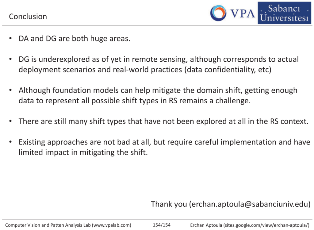
In his presentations, Prof. Erchan Aptoula addressed the concepts of domain adaptation and domain generalization in the context of remote sensing, with a focus on the challenges posed by the domain shift phenomenon.
He formalized domain shift and present where it can manifest in in remote sensing along with domain adaptation (DA) and Domain Generalisation (DG) approaches.
Throughout the session, Prof. Aptoula integrated visual examples from optical and synthetic aperture radar (SAR) imagery, demonstrating the effect of domain shift and the improvements achievable through DA and DG methods.
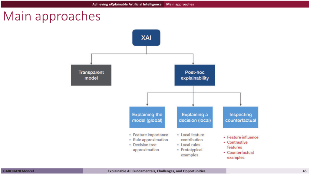
Slide from Dr. Moncef Garouani presentation
XAI: Fundamentals, Challenges and Opportunities for Agriculture
In his presentation, Dr. Moncef Garouani introduced the fundamentals of Explainable AI (XAI), highlighting its importance in ensuring transparency, trust, and accountability in artificial intelligence systems.
The session explored key concepts such as global versus local interpretability, post-hoc versus intrinsic explainability, and model-specific versus model-agnostic approaches, providing detailed explanations for techniques pertaining to each concept.
The presentation was followed by the exploration of notebook based examples, allowing participants to have an XAI hands-on experience.
Day 3: Advances in Remote Sensing for Agriculture
Slide from Prof. Fabio Del Frate presentation
Advanced Remote Sensing Techniques for Agriculture
In his presentation, Prof. Fabio Del Frate introduced and explore advanced remote sensing techniques for agricultural monitoring and research, covering the principles, technologies, and applications of both hyperspectral and radar remote sensing.
Through this presentation he highlighted these technologies ability to provide detailed information about crops, soil, and vegetation at various scales as well as the need for dimensionality reduction techniques in order to efficiently process large scale remote sensing data.
Slide from Dr. Ilaria Petracca presentation
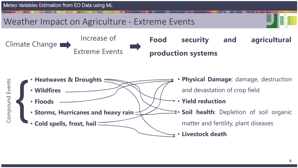
Meteo Variables Estimation from EO Data using Machine Learning
Dr. Ilaria Petracca presentation demonstrated how Earth Observation data, combined with machine learning, can be used to estimate meteorological variables for monitoring extreme events and environmental hazards.
Through this presentation, Dr. Petracca introduced global environmental challenges such as climate change and extreme weather, their impact on agriculture, and the role of Earth Observation technologies and AI in monitoring and mitigating these effects.
She presented two case studies of deep learning applied to Earth Observation: first on Ida hurricane with a methodology for retrieving precipitation in tropical cyclones, then on Raikoke 2019 volcanic eruption event for volcanic ash plumes monitoring.
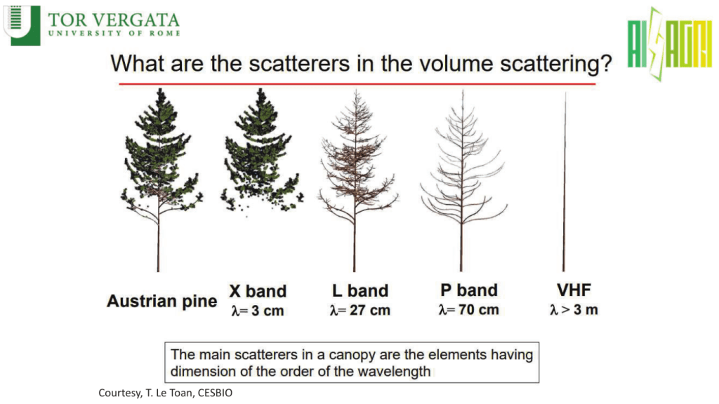
Slide from Dr. Antonio Di Noia presentation
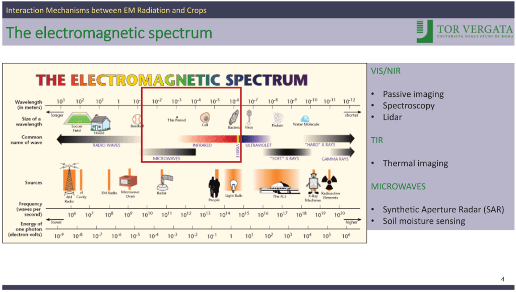
Interaction Mechanisms between Electromagnetic Radiation and Crops
In his presentation, Dr. Antonio Di Noia presented how electromagnetic radiation interacts with agricultural crops, linking fundamental theory to practical remote sensing applications.
He described how different parts of the electromagnetic spectrum, from visible to microwave regions, are used to observe crops, and how plant characteristics such as pigment content, water levels, and structural arrangement affect the way radiation is absorbed, reflected, or scattered.
Through his presentation, he illustrated how these interactions form the basis for interpreting satellite and airborne observations in agriculture.
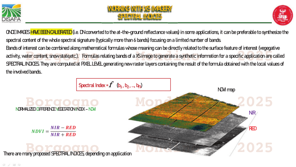
Slide from Prof. Enrico Borgogno Mondino presentation
Spectral Indices (Time Series)
In his presentation, Prof. Enrico Borgogno Mondino focused on the use of spectral indices from satellite imagery time series for monitoring agricultural systems.
He reviewed widely used indices such as NDVI and EVI, explaining their link to plant health indicators like chlorophyll content, biomass, and water status. He presented how time series of these indices allows tracking crop growth cycles, detecting anomalies, and estimating yields.
Prof. Borgogno Mondino also discussed the steps needed to produce reliable time series, including cloud masking, and filling the gaps in temporal profiles.
Day 4: Data Preparation and Preprocessing
Slide from Dr. Yajing Yan presentation
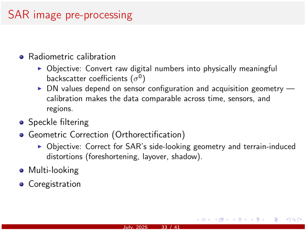
SAR Image Data Processing and Analysis
Dr. Yajin Yan presentation covered key aspects of SAR image acquisition and how these relate to soil, crop structure, and water conditions as well as common distortions and their correction.
Agricultural applications were presented, including monitoring crop growth, detecting floods, and estimating soil moisture.
A practical example illustrated the end-to-end process of downloading, calibrating, debursting, multilooking, and terrain-correcting Sentinel-1 SAR data for agricultural monitoring.
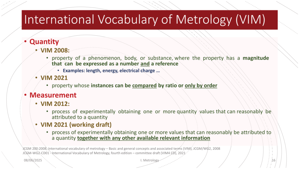
Slide from Dr. Noël Richard presentation
Metrological Feature Spaces
Dr. Noël Richard presented a framework for describing and comparing textures in images through a metrological, measurement-focused approach.
The talk included definitions of texture and a categorization of existing methods assessed against metrological criteria.
It also examined measurement principles, feature extraction techniques, and multivariate approaches, concluding with proposals for feature spaces that preserve physical meaning and are robust across sensors and contexts.
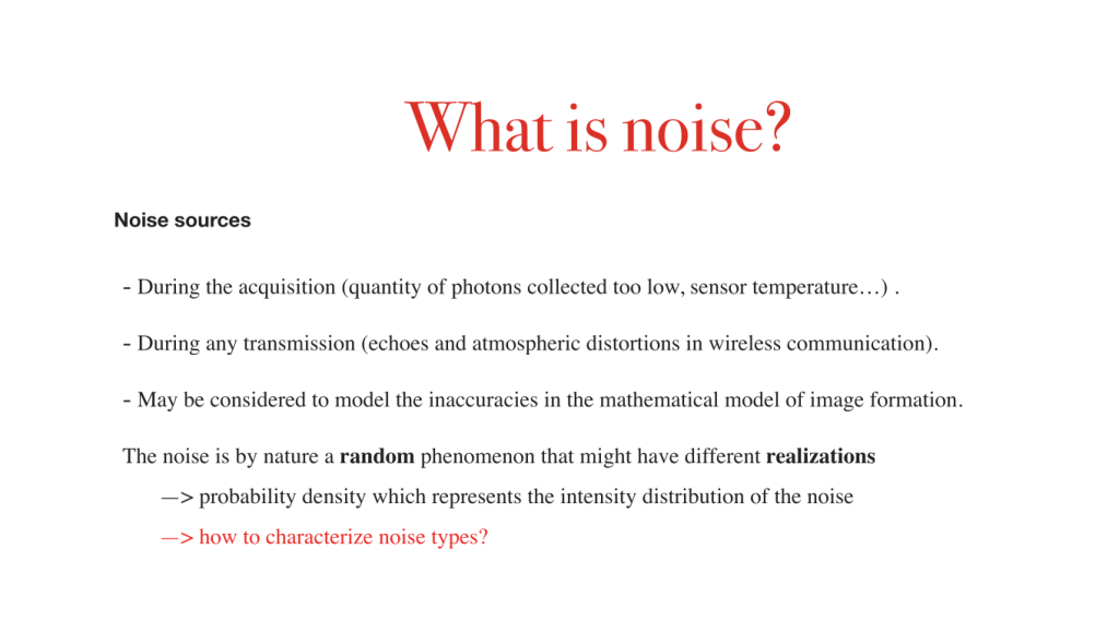
Slide from Prof. Lotfi Chaari presentation
Image Denoising: from Inverse Problems to Deep Learning
In his presentation, Prof. Lotfi Chaari explained the principles, challenges, and modern approaches to removing noise from images.
He defined noise, its sources, and types, exploring how to quantify noise through measures such as SNR.
Through this presentation, Lotfi Chaari showed the evolution from traditional model-based techniques to modern hybrid and deep learning methods, highlighting how each approach addresses denoising challenges in different contexts.
Exercice snippet from Dr. Ioana Cristina Plajer workshop
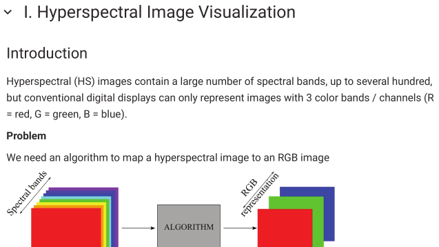
Multi and Hyper-Spectral Image Visualization using AI
At the AI4AGRI Summer School, Dr. Ioana Cristina Plajer presented practical examples on visualizing multi and hyperspectral satellite images for agricultural monitoring. Using PRISMA and Sentinel-2 data, participants learned how to access, inspect, and convert raw spectral files into interpretable RGB images.
The session covered choosing spectral bands to highlight vegetation and land features, enhancing contrast with histogram equalization, creation of RGB images from Sentinel-2 data, use of spectral interpolation, AI-based hyperspectral data visualization, and NDVI calculation.
Day 5: More Big Data and Applications in Agriculture
Slide from Assoc. Prof. Alexandra Băicoianu and MSc Student Matei Debu presentation
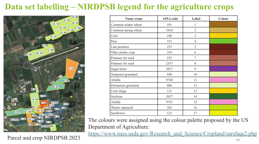
DACIA5 Data Set and Applications
The presentation by Associate Professor Alexandra Băicoianu and Master Student Matei Debu introduced the DACIA5 dataset, a collection of satellite imagery from agricultural fields north of Brașov. It combines Sentinel‑2 multi-spectral and Sentinel‑1 radar satellite data with field-verified crop information to support agricultural monitoring and research.
They explained how the dataset was prepared, from acquiring and processing satellite images to organizing the data into clear, labelled crop maps.
Their presentation ended with an open call to participate in the DACIA5 Data challenge.
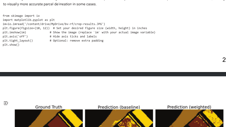
Snippet from Assoc. Prof. Alexandra Băicoianu demonstration of DACIA5 use
Workshop: RestNet18-based Crop Identification
Associate Professor Alexandra Băicoianu guided AI4AGRI Summer School participants through a workshop on deep learning based DACIA-5 dataset crop identification.
Her workshop featured adapting a ResNet18 to 12-channel multispectral inputs, covering data preprocessing, normalization, model training, and evaluation. Attendees learned about modifying network layers, tracking accuracy, and performing inference on unseen data.
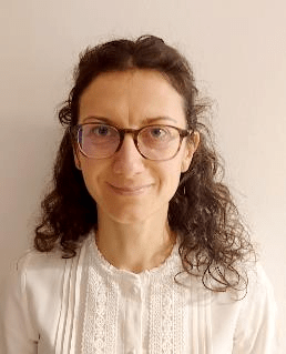
Snippent from Dr. Andrei Racovițeanu demonstration of DACIA5 use
Workshop: MLP-based Crop Identification
Dr. Andrei Racovițeanu organised a workshop on applying Multi-Layer Perceptrons-based crop classification in a class imbalance setting, covering methods for inspecting datasets, evaluating training results, and generating performance metrics from model predictions.
The workshop featured a presentation of the fundamentals of Multi-Layer Perceptrons, including architecture configurations such as hidden layer sizes and learning rates and how weighting loss can help to mitigate class inbalance.

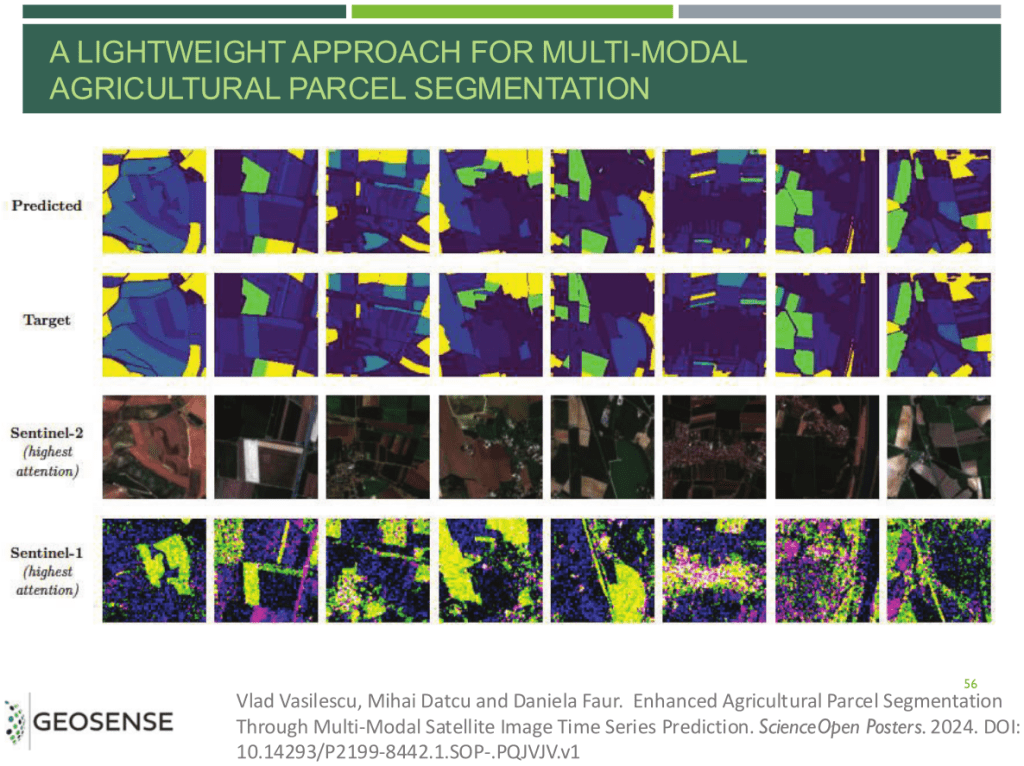
Slide from Assoc. Prof. Daniela Faur presentation
EO Data Applications in Agriculture
Associate Professor Daniela Faur introduced digital agriculture as a way to use remote sensing, sensors, AI, and software to collect farm data and improve decision-making. She also explained how electromagnetic radiation interacts with the Earth and how NDVI can be used to estimate biomass.
She presented the four main types of remote-sensing resolutions and explained their impact on image detail. The differences between multispectral and hyperspectral sensors were highlighted, with Sentinel-2 used as a practical example of hyperspectral imaging.
She presented AI applications such as parcel segmentation with optical and radar data, and NDVI forecasting using LSTM models.
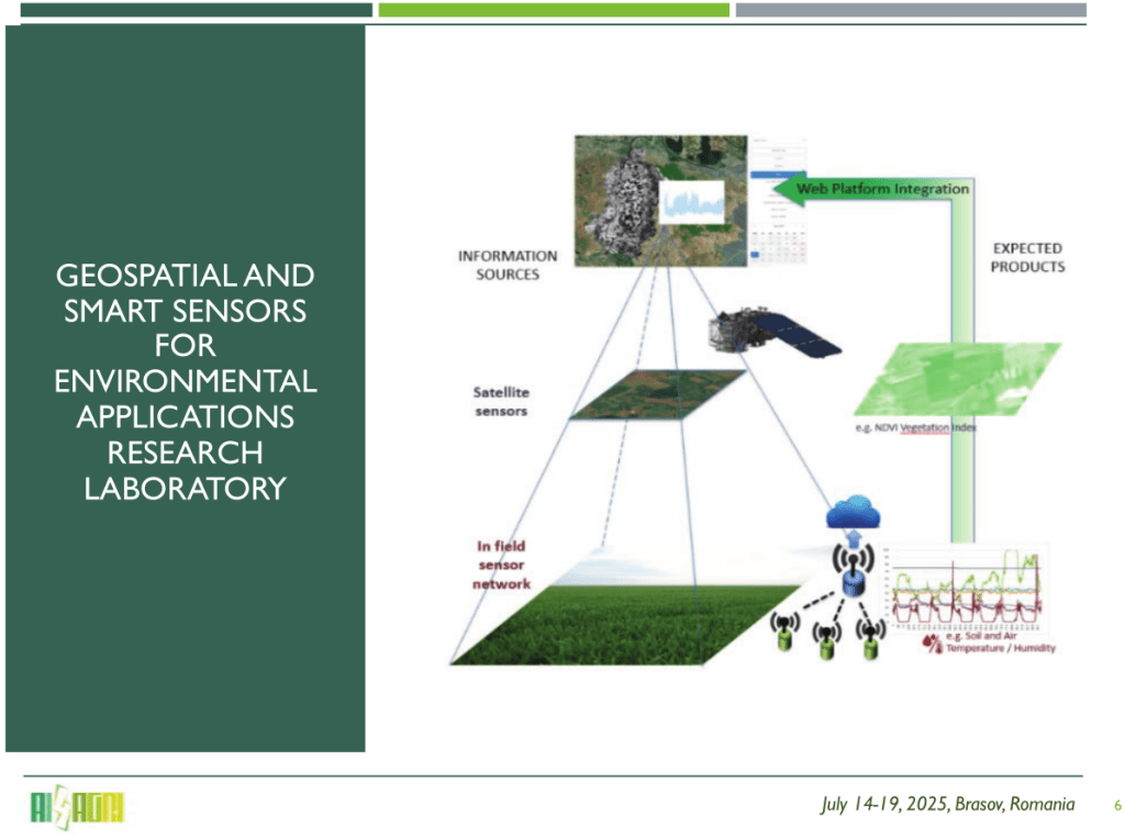
Slide from Dragoș-Ioan Săcăleanu presentation
In-field Environmental Parameters Monitoring
Dragoș‑Ioan Săcăleanu‘s presented his work on monitoring in‑field environmental parameters using wireless sensor networks, explainin the architecture of sensor nodes, communication protocols and broad application areas.
He presented several research projects, including platforms integrating satellite imagery and ground sensors, microclimate control in greenhouses, intelligent IoT systems for greenhouse automation, machine‑learning‑based decision support systems for farmers.
Day 6: Brunch in the potato field and conclusion
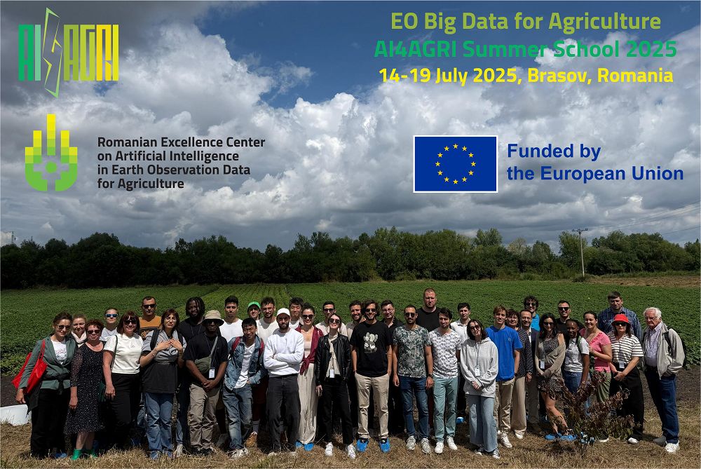
Group picture in the potato field
The AI4AGRI Summer School 2025 ended on Saturday, 19 July, with a brunch in the potato field, where participants took part in hands-on activities such as measuring soil and plant parameters in potato crops and attending live demonstrations of crop monitoring equipment by Romanian companies AgriCloud SRL (Călărași County) and Carfil SA (Brașov).
This event concluded a successful program that brought together participants from across the world, highlighted the strength of the AI4AGRI network, and encouraged the exchange of knowledge and practical skills. It showcased the expertise developed at the AI4AGRI Romanian Excellence Center on Artificial Intelligence for Earth Observation in Agriculture, complemented by contributions from international specialists, and strengthened links within the wider EO and AI-assisted agriculture community.
Publishing managers: J. Mothe & S. Molina, UT3 & UT2, IRIT, France