
Member highlight: Antonio Di Noia – Tor Vergata University, Roma (Italy)
Antonio Di Noia received his M. S., cum laude, in Telecommunications engineering and his Ph. D. in Geoinformation from the Tor Vergata University of Rome in 2009 and 2013, respectively.
He currently holds an assistant professor position at the same university, after holding post-doctoral positions at Space Research Organisation Netherlands (SRON), University of Leicester (United Kingdom) and University of Bremen (Germany). His research interests revolve around satellite remote sensing of the atmospheric composition, with particular focus on multi-angular polarimetry of aerosols and clouds at optical wavelengths, and on greenhouse gas remote sensing from passive shortwave infrared (SWIR) measurements.
As part of his research activities, he has contributed to scientific studies in preparation of the satellite instruments SpexOne, dedicated to aerosol remote sensing and launched in February 2024 as part of the NASA PACE mission, and the forthcoming European CO2 Monitoring mission CO2M, planned for launch in 2026. He has acted as a reviewer for a number of journals which include Atmospheric Measurement Techniques, Applied Optics, Journal of Quantitative Spectroscopy and Radiative Transfer and Remote Sensing of Environment, and has been a guest editor for the research topic “Application of Machine Learning for the Acceleration of Radiative Transfer Modelling and Inversion” for Frontiers in Remote Sensing.
Since 2024 he is teaching the courses Electromagnetic Fields and Microwaves at the Tor Vergata University of Rome.
News
AI4AGRI Monthly meeting
📅 Mon. 12 May – 14:00 (Fr/It time) | 15:00 (Ro time)
AI4AGRI Presented at SEEN Entrepreneurship Course
📅 Mon. 7 – Fri. 11 April 2025
📍 Brașov, Romania
The AI4AGRI project and its activities were presented by Mihai Ivanovici during the Erasmus+ SEEN (Social Entrepreneurship Ecosystems Network) pilot course held from 7th to 11th April 2025. The event explored the intersection of artificial intelligence and social entrepreneurship, offering participants insights into AI tools for entrepreneurial development alongside human-centered competencies essential for navigating current societal challenges.
AI4AGRI Upcoming Events

AI4AGRI Summer School 2025: EO Big Data for Agriculture
📅 Mon. 14 – Sat. 19 July 2025
📍 Brașov, Romania
The AI4AGRI summer school is planned to take place between 14-19 July 2025 in Brasov, Romania, being hosted by the R&D Institute of Transilvania University of Brasov.
Participation to the AI4AGRI Summer School 2025 is for free and it will be face-to-face (in person). The organization and participation costs, including catering, are paid by the AI4AGRI project, however the AI4AGRI project will not cover for the travelling and other mission-related costs.
The applications are now closed as of 1st of May, if you have applied please wait for our feedback.
Latest AI4AGRI Publications
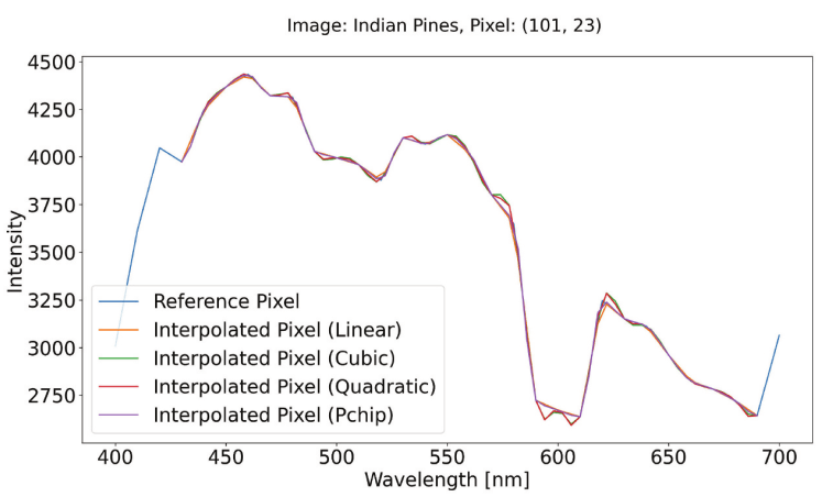
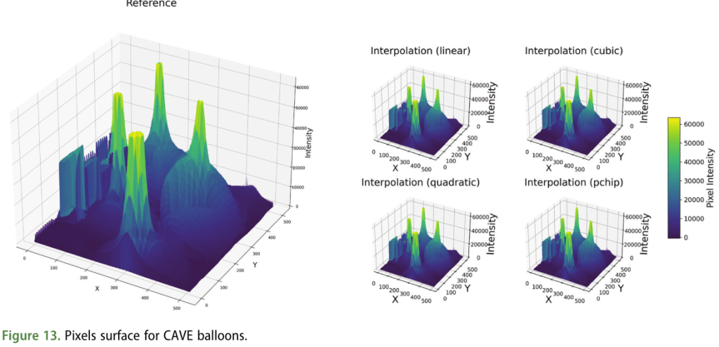
Spectral Image Data Fusion for Multisource Data Augmentation
🧑 Roberta Iuliana Luca | Alexandra Băicoianu | Ioana Cristina Plajer
📅 2025
Multispectral and hyperspectral images are increasingly popular in different research fields, such as remote sensing, astronomical imaging, or precision agriculture. However, the amount of free data available to perform machine learning tasks is relatively small. Moreover, artificial intelligence models developed in the area of spectral imaging require input images with a fixed spectral signature, expecting the data to have the same number of spectral bands or the same spectral resolution. This requirement significantly reduces the number of usable sources that can be used for a given model. The scope of this study is to introduce a methodology for spectral image data aggregation, in order to allow machine learning models to be trained and/or used on data from a larger number of sources, thus providing better generalization. For this purpose, we propose different interpolation techniques, in order to make multisource spectral data compatible with each other. The interpolation outcomes are evaluated through various approaches. This includes direct assessments using surface plots and metrics such as a Custom Mean Squared Error and the Normalized Difference Vegetation Index. Additionally, indirect evaluation is done by estimating their impact on machine learning model training, particularly for semantic segmentation.
Luca, R.I., Baicoianu, A. and Plajer, I.C., 2025. Spectral image data aggregation for multisource data augmentation. European Journal of Remote Sensing, 58(1), p.2492295.
https://www.tandfonline.com/doi/full/10.1080/22797254.2025.2492295
Related Upcoming Events

🧑 THEIA, FORMATERRE, and PNDB (Data Terra)
📅 Mon. 26 – Wed. 28 May 2025
📍 Jardin Botanique Alpin du Lautaret, France
A 3-day workshop focused on mountain environments and climate challenges, organized by THEIA, FORMATERRE, and PNDB (Data Terra). Key themes:
- Water resources and climate change
- Mountain ecology and biodiversity
- Extreme events: understanding and management
A special session on May 28 by the C2ROP project will explore remote sensing for landslide monitoring, including site visits. Open to researchers, institutions, and end users of Earth observation data.
Webinar – “Understanding and Governing the Destabilization of Socio-Technical Systems”
🧑 Bruno Turnheim – INRAe, LISIS
📅 Tue. 6 May 2025, 13:30 to 14:30 (FR)
📍 Online
Bruno Turnheim is a researcher at the National Institute for Agriculture, Food, and Environment (INRAE) within the Interdisciplinary Laboratory of Science, Innovation, and Societies (LISIS), University Gustave Eiffel. Specializing in socio-technical transitions, he investigates the destabilization of established regimes in sectors such as energy, mobility, and food. He coordinates the WAYS-OUT project on the governance of dominant system exits and actively contributes to the Sustainability Transitions Research Network (STRN).
Webinar – INRAE Remote Sensing Network: Theia Data and Services Centre in Montpellier
🧑 THEIA, FORMATERRE, and PNDB (Data Terra)
📅 Tue. 3 June 2025, 14:00 (FR)
📍 Online
This webinar focuses on the Theia Data and Services Centre (CDS) in Montpellier, which provides services to ease use of geospatial data from satellite imagery. The CDS utilizes open-source tools, cloud-native approaches, and standards like STAC and COG to manage large datasets efficiently. It draws inspiration from the “Microsoft Planetary Computer” and facilitates advanced data processing for Earth observation.
More info: CDS Theia Montpellier
Related Publications
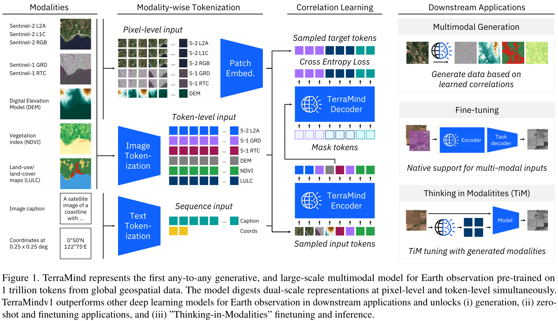
TerraMind: Large-Scale Generative Multimodality for Earth Observation
🧑 Johannes Jakubik et al.
📅 2025
“We present TerraMind, the first any-to-any generative, multimodal foundation model for Earth observation (EO). Unlike other multimodal models, TerraMind is pretrained on dual-scale representations combining both token-level and pixel-level data across modalities. On a token level, TerraMind encodes high-level contextual information to learn cross-modal relationships, while on a pixel level, TerraMind leverages fine-grained representations to capture critical spatial nuances. We pretrained TerraMind on nine geospatial modalities of a global, large-scale dataset. In this paper, we demonstrate that (i) TerraMind’s dual-scale early fusion approach unlocks a range of zero-shot and few-shot applications for Earth observation, (ii) TerraMind introduces “Thinking-in-Modalities” (TiM) — the capability of generating additional artificial data during finetuning and inference to improve the model output — and (iii) TerraMind achieves beyond state-of-the-art performance in community-standard benchmarks for EO like PANGAEA. The pretraining dataset, the model weights, and our code is open-sourced under a permissive license.”
Related projects in AI, Agriculture and Earth Observation

Call for Projects: Postdoctoral Contracts in Occitanie for O3T Project
📅 Deadline: July 21, 2025
A new call is open to fund postdoctoral research contracts in the Occitanie region, as part of the multidisciplinary project O3T – Earth Observation and Territories in Transition.
The projects must address at least one of the following three research axes:
- Low-cost instrumentation (e.g. field measurements, affordable sensors)
- Data retrieval and exploitation (storage, processing, analysis, visualization, sharing)
- Operationalization, awareness-raising, and co-construction of data and observatories with territories (collaborative frameworks between researchers and local actors)
Targeted environments include urban, rural, coastal, and mountain areas. Projects must respond to concrete operational needs tied to territorial transitions and demonstrate strong practical relevance.
Priority will be given to initiatives that include a 2–6 month immersion in an operational structure (e.g. local authority, NGO, national park, state agency, or social sciences lab active in fieldwork).
More info: https://o3t.univ-toulouse.fr/lancement-dun-nouvel-aap-pour-le-financement-de-contrats-postdoctoraux/
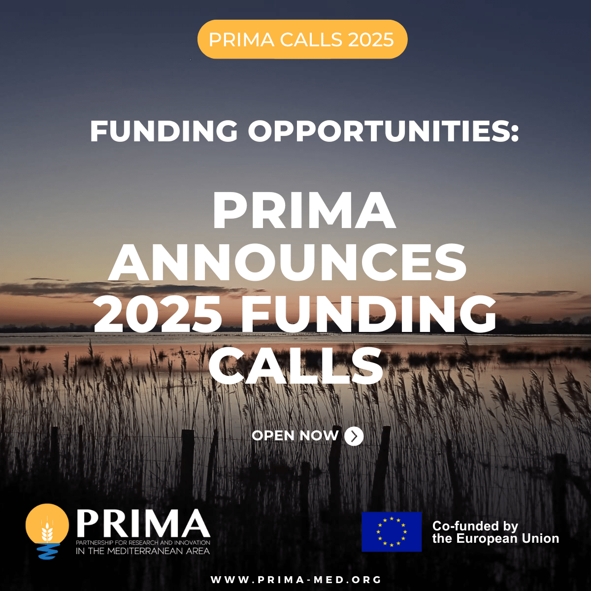
PRIMA 2025 Calls for Proposals – Funding Opportunities Across the Mediterranean sea
📅 Deadlines: 15 July 2025 ( Section 1) | 8 July 2025 (Section 2)
The 2025 calls for proposals under the PRIMA program (Partnership for Research and Innovation in the Mediterranean Area) are now open, supporting research and innovation tackling water management and agri-food systems in the Mediterranean.
Key Themes:
- Water management: Advanced digital tools (AI, IoT) for adaptive management, with a focus on impact assessments for policy development
- Agricultural systems: Precision farming for smallholders, promoting biodiversity, soil health, and inclusive practices
- Agri-food value chains: Encouraging sustainable consumer choices, expanding plant-based protein options, and improving traceability
Funding Structure:
- Section 1 (EU-funded): 3 thematic calls, ~12 projects expected, €2.7M each, deadline: 15 July 2025
- Section 2 (nationally funded): 1 cross-cutting call, ~20 projects expected, €1.5M each, deadline: 8 July 2025
https://prima-med.org/funding-opportunities-prima-2025s-calls-are-now-open/
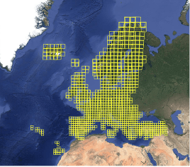
Reprocessing Sentinel-2 data: A new step towards better quality
As part of the THEIA program, the CDS THEIA team at CNES announces the progressive release of data derived from the reprocessing of the Sentinel-2 level 2A archive on the GEODES platform. This reprocessing covers over nine years of acquisitions, from July 4, 2015, to December 31, 2024. The process starts with the European zone and will extend to other regions, including India, Africa, and the Americas. The goal is to improve data quality by correcting location errors and optimizing multi-temporal overlap.
Access tools are being developed to facilitate downloading the reprocessed data.
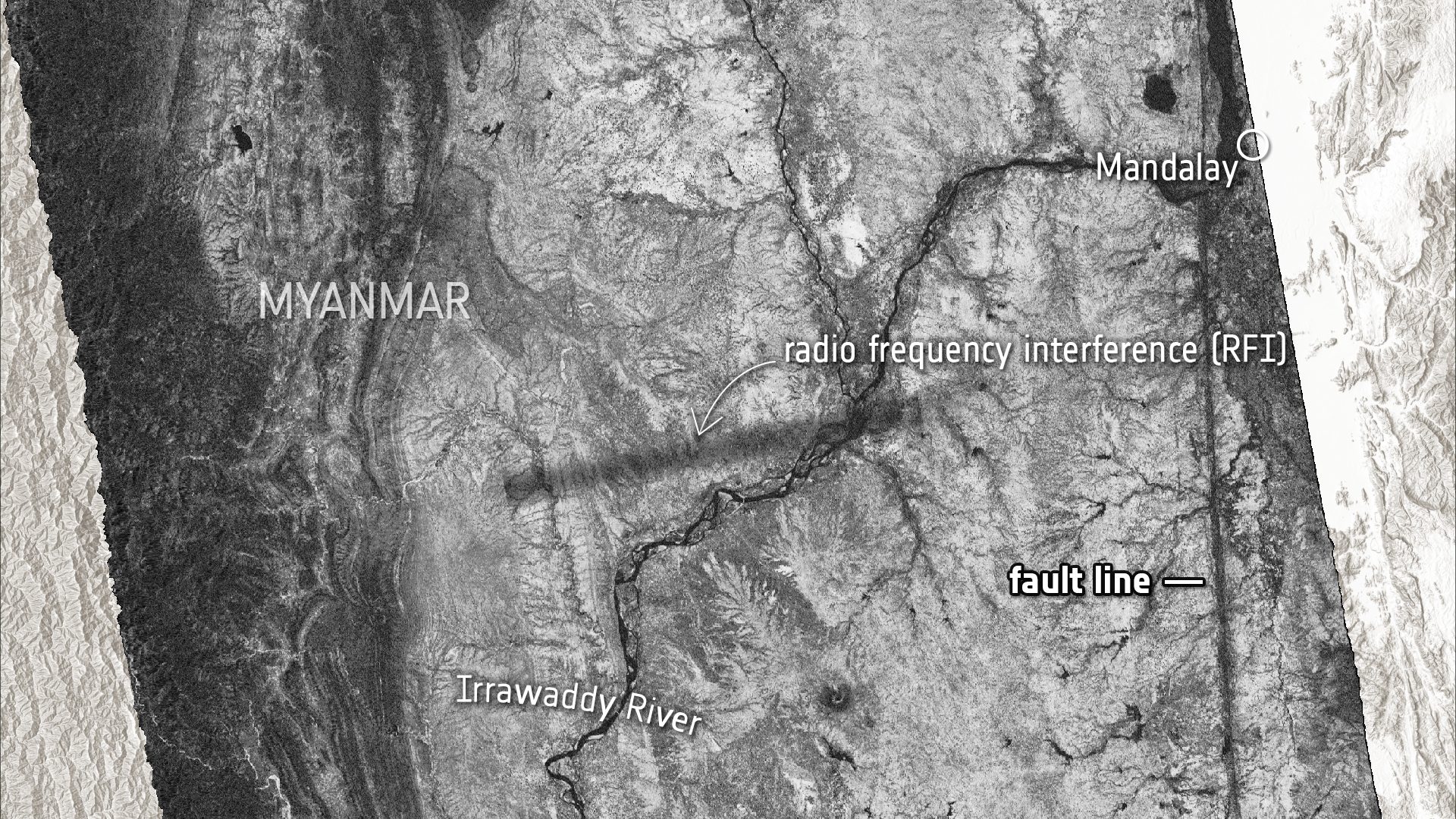
Applications Myanmar interferogram and coherence map from Copernicus Sentinel-1 © DLR Microwave & Radar Institute/ESA – ESA Standard Licence
Sentinel-1 captures ground shift from Myanmar earthquake
“On 28 March 2025, a powerful magnitude 7.7 earthquake struck central Myanmar, sending shockwaves through the region. While the country is still dealing with the devasting aftermath, scientists have used radar images from the Copernicus Sentinel-1 satellites to reveal a detailed picture of how the ground shifted as a result of the quake – offering new insights into the mechanics of the tectonic Sagaing Fault and the scale of the seismic rupture.“
Biomass satellite launched aboard a Vega-C rocket from Kourou, French Guiana
“ESA’s groundbreaking Biomass satellite, designed to provide unprecedented insights into the world’s forests and their crucial role in Earth’s carbon cycle, has been launched. The satellite lifted off aboard a Vega-C rocket from Europe’s Spaceport in Kourou, French Guiana, on 29 April at 11:15 CEST (06:15 local time).“
The AI4AGRI project received funding from the European Union’s Horizon Europe research and innovation program under the grant agreement no. 101079136.
Publishing managers: J. Mothe & S. Molina, UT3 & UT2, IRIT, France